
English
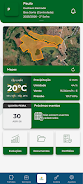
PRIME Agrotecnologia is a client-only mobile application that brings precision agriculture tools directly to technicians and rural producers, helping them manage soil fertility and plant nutrition through georeferenced data and remote sensing. Designed for use across diverse Brazilian agricultural landscapes, PRIME Agrotecnologia consolidates field information, spatial variability analysis and geostatistics into an accessible mobile interface so teams can monitor productivity trends, diagnose issues and make more objective, cost-effective management decisions.
The app centralizes georeferenced layers and remote-sensing inputs to reveal spatial variability within paddocks and growing areas. Users can view soil and plant nutrition indicators alongside productivity metrics to identify zones that need targeted intervention. Built-in spatial analysis and geostatistical tools support zoning and sampling strategies, while time-series visualizations help evaluate the impact of management changes. Access is client-restricted, ensuring that sensitive farm data stays private and available only to authorized agronomy teams.
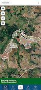
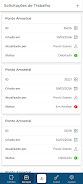
Navigation emphasizes simple map-centric controls: pan and zoom gestures to explore fields, tap-to-select polygons to inspect individual management zones, and layer toggles to combine satellite imagery with soil and yield data. Menus are organized around field lists, sample points and reports so technicians can move from overview to detail quickly. The interface is optimized for touch interaction and common field tasks, reducing the number of steps required to access key indicators during on-site visits.
PRIME Agrotecnologia supports a clear progression from raw observations to actionable recommendations. As users add samples, surveys or sensor inputs over multiple seasons, the app aggregates those records to refine spatial models and improve decision confidence. Progression is tracked through period-to-period comparisons that let teams quantify productivity evolution and assess whether interventions led to measurable gains or require adjustments in subsequent cycles.
Visual presentation focuses on clarity and contextual detail. Field boundaries, management zones and sampling points are rendered with distinct symbols and color ramps to make patterns immediately visible. Heatmaps and contour layers display variability in nutrients or productivity, while satellite basemaps supply seasonal context. The map structure is layered so users can customize what they see and combine datasets to support diagnosis and planning.
The application allows customization of analysis parameters and display preferences to match local agronomic practices. Users can define management thresholds, set sampling interval preferences and tailor the map legend to emphasize the variables most relevant to their crops. Role-based access ensures that technicians and producers see the appropriate level of detail, and configuration options help embed the app into existing workflows rather than forcing a one-size-fits-all approach.
Recognizing that connectivity in rural areas can be intermittent, the app provides offline-capable workflows so core data and maps can be cached for field visits. When a connection is re-established, collected observations synchronize with central systems to keep records current. For reliable performance the app requires modern Android devices; recommended minimum specifications include Android 9.0 or later with 4 GB of RAM and multi-core processors to handle map rendering and spatial computations.
The utility of PRIME Agrotecnologia grows with repeated use: season-over-season records enable trend analysis, improved sampling strategies and smarter allocation of inputs. Teams repeatedly consult the app during planning, scouting and post-harvest review, turning a single-season snapshot into a longitudinal management tool. This iterative use increases the precision of recommendations and supports continuous improvement in both agronomic decisions and cost-effectiveness.
Bentevi, the developer behind the app, specializes in soil fertility management and plant nutrition and provides documentation and onboarding to help client teams adopt the system. Training focuses on interpreting spatial outputs and integrating app-derived insights into field operations. Support channels emphasize data privacy, secure client access and practical assistance with geospatial workflows so agronomy teams can concentrate on agronomic decisions rather than technical hurdles.
Because PRIME Agrotecnologia is intended for authorized clients, it is not available for general public download; organizations interested in the platform should contact the developer for access. The app is optimized for technicians and rural producers who work with field sampling and spatial planning and expect to use georeferenced and remote-sensing data as part of their decision process. Users should consider device performance when operating large datasets or performing complex geostatistical analyses.

Resume Review
Size:48.00M ProductivityPearDrop
Size:124.00M ProductivityBetfury
Size:17.00M ProductivityPRIME Agrotecnologia
Size:66.94M ProductivityTerra Nativa
Size:64.00M ProductivityAgrotti
Size:67.76M ProductivityVyMerge
Size:61.92M ProductivityNitro Pdf Editor
Size:40.00M ProductivityClubUp Caddies
Size:39.00M ProductivityBrushByte Odyssey
Size:28.54M ProductivityBulletProof
Size:171.44M ProductivityPorcentagem Total
Size:22.00M ProductivityApril 2024 Clash of Clans Update: Unveiling a Fresh Companion, Enhanced Levels, Chat Tagging, and Be
2024-04-16Arrival of Genshin Impact 4.6 Update: 'Embers of Two Realms, Twilight of Crimson'
2024-04-16V2.2 of the Farlight 84 update introduces an overhauled Season structure, fresh in-game currency, an
2024-04-16Monster Never Cry is now accessible on both Android and iOS mobile devices.
2024-04-18PUBG Mobile Teams Up with Bentley Motors: Luxury Cars, Exclusive Collectibles, and Beyond
2024-04-18March 2024 Free Redemption Codes for Honkai: Star Rail
2024-04-18