English
Furaha Baraka Farms is a digital platform designed to bring transparency, operational control and measurable impact to tree planting and conservation projects. The app tracks the full tree lifecycle from seed reception in nurseries through planting, post-planting monitoring and survival reporting, combining GPS, timestamped photos and simple field forms so farmers, donors and project managers can verify every sapling and follow progress in near real time. Users install it to coordinate nursery inventory, assign deliveries, monitor driver and field activity, and generate exportable reports that support audits and funding decisions.
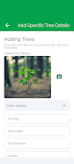
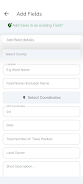
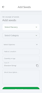
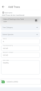
The application centralizes several everyday workflows into a single interface. Nursery staff log seed batches and seedling quality, drivers confirm pickups and dropoffs with QR codes and geotagged photos, and field officers record planting events and survival checks. Donors can view sponsored trees on maps and download impact summaries while administrators run filters and exports for monitoring and compliance. Built-in photo evidence, GPS coordinates and timestamps help reduce disputes over locations and status, and configurable report templates allow teams to tailor output to funder requirements.
Interaction is focused on intuitive controls adapted to field conditions. Large, touch-friendly forms minimize typing on small screens, map views allow tapping to view individual tree records, and a guided scan flow simplifies QR-code verification for nursery lots and planted trees. Role-based dashboards present only relevant actions and KPIs to each user type, reducing clutter and training time. Upload progress indicators, simple swipe actions to move tasks between states, and contextual help texts are woven into the interface to support quick adoption by busy field teams.
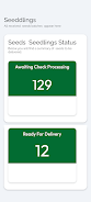
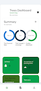
Projects are organized into clear stages such as nursery intake, dispatch, planting, monitoring and reporting. Each tree or lot moves through these stages so project managers can measure progress against milestones and calculate survival rates over specified intervals. Impact reporting includes maps, cumulative counts and time series that show survival trends, enabling better decisions about species selection, planting density and maintenance schedules. Managers can set checkpoints and reminders to keep planting cycles on track.
The app emphasizes map-driven navigation and photographic evidence for quick verification in the field. Map layers show nursery locations, planting sites and donor-sponsored parcels, while photo galleries attached to each record provide chronological visual histories. The interface favors high-contrast elements for outdoor readability, scalable icons for quick scanning and clear date stamps to make audit trails straightforward during reviews and field inspections.
Administrators can customize dashboards, notification thresholds and report layouts so each role sees the most relevant data. Role-based permissions limit access to sensitive controls while allowing contributors to submit field entries. Notification settings can be tuned for low-bandwidth environments so teams receive essential updates without unnecessary data use. These customization options help align the app with varied organizational workflows and donor reporting standards.
The app is designed to handle intermittent connectivity common in remote planting areas by allowing data entry while offline and queuing uploads once a connection is available. GPS readings and photos are cached locally with timestamps so records remain verifiable after sync. Validation checks and required field prompts reduce the chance of incomplete records, and audit logs preserve an edit history for critical entries to support later verification and reconciliation.
Usability is a priority, with simplified forms, clear visuals and short in-app tutorials to shorten the learning curve. Role-specific workflows reduce cognitive load and allow new users to repeat standard tasks reliably, which improves consistency across planting seasons. The app supports repeated seasonal projects and multi-year monitoring campaigns, making it valuable for organizations that run cyclical planting programs and need consistent longitudinal data.
Accurate tracking does depend on GPS coverage and photo quality, and field teams may require training to use QR-code verification and role-specific dashboards effectively. Full functionality is strongest when contributors enter consistent, timely data, so project managers should plan for verification visits and routine data audits. Despite these constraints, Furaha Baraka Farms makes it considerably easier for donors, farmers and organizations to verify contributions and monitor environmental impact.
Furaha Baraka Farms Limited developed the app with a focus on improving transparency, traceability and operational efficiency across nurseries, donors and field teams. The team continues to refine offline reliability, reporting flexibility and usability based on feedback from real-world projects and partner organizations.


Furaha Baraka Farms
Size:50.99M ToolsSmart Budget Tracker
Size:40.91M ToolsDiablo BT
Size:18.83M ToolsTV Brasil - TV ao Vivo
Size:20.81M ToolsPetmo
Size:71.21M Toolstodo
Size:31.22M ToolsCleaner Mate
Size:23.20M ToolsTranslate All Language
Size:14.64M ToolsJoker's Carousel
Size:11.00M ToolsCoral Pale Quokka Lynx
Size:15.00M ToolsClyoXVPN
Size:109.04M ToolsPerfect Trans
Size:19.60M ToolsApril 2024 Clash of Clans Update: Unveiling a Fresh Companion, Enhanced Levels, Chat Tagging, and Be
2024-04-16Arrival of Genshin Impact 4.6 Update: 'Embers of Two Realms, Twilight of Crimson'
2024-04-16V2.2 of the Farlight 84 update introduces an overhauled Season structure, fresh in-game currency, an
2024-04-16Monster Never Cry is now accessible on both Android and iOS mobile devices.
2024-04-18PUBG Mobile Teams Up with Bentley Motors: Luxury Cars, Exclusive Collectibles, and Beyond
2024-04-18March 2024 Free Redemption Codes for Honkai: Star Rail
2024-04-18